
It’s been a month since level 4 water restrictions were imposed in our area by Bitou Municipality. We have had some good rains, road verges and gardens have turned green again and so it seems everything is back to normal – so why is there still talk about a pending “water crisis” in Plettenberg Bay?
In a recent post on “Plett in Stereo” the author comments as follows: “After the follow up rain last week, the flow was exceeding 5190 liters per second (12 February 2026). This measuring weir is located below the off take of the Bitou Municipality pump station. We therefore do not now have a water crisis as we still have a desalination plant and the 2 wells to top up the water supply to Plettenberg Bay.”
True or false? That depends on how you look at things: As a short-term ‘snapshot’ of the status quo the above statement is factually correct – the Keurbooms River provides more than enough water at present. However, if we had to rely on the desalination plant and the two wells only, the picture would already look quite different as even the combined capacity of these three sources would not suffice to meet demand.
The real problem though is that the healthy flow rate of the Keurbooms is bound to fluctuate significantly as soon as we hit the next dry spell. Take a look at this graph which shows how the flow rate developed over the past month, from 19 January to 18 February 2026 and you will immediately see how quickly and drastically things might change:
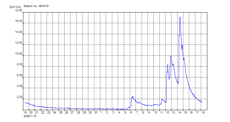
This morning, 18 February at 7:36 am the flow rate stood at 1.416 liters/second. Four days ago it peeked at just over 17.000 liters/second – that’s tenfold of today’s amount. Extrapolate this tendency and you get the idea quickly.
Why does the river’s flow rate fluctuate so drastically? Obviously, strong rains in the catchment area have a massive effect. But that’s exactly where the first problem lies – we can no longer rely on these rains to be consistent. And the second problem is: the degradation of the catchment areas coupled with land usage change dramatically reduce the amount of water that reaches us downstream.
Indeed, the long term forecasts for our area paint a bleak picture. Almost 20 years ago the Gouritz State of the Rivers Report (GSRR) listed the characteristics, benefits and issues associated with the rivers of the Southern Cape. According to this report indications were that South Africa would reach its limits of accessible water supply between 2020 and 2030. This is why water resources in the Garden Route are now under severe threat and why our water demand is unsustainable. More specifically, back in 2004 the Department of Water Affair’s Internal Strategic Perspective for the Gouritz Water Management Area (which incorporates the rivers of the Southern Cape) estimated that by 2020 there would be a shortfall of 43 million cubic metres per annum for the Garden Route and 10 million cubic metres per annum for the Knysna to Bloukrans area. (This document is available for download here).
In a more recent document titled “Western Cape Water Resilience Strategy: Future Proofing our water security 2025-2035” (which you can download here) the Western Cape’s Department of Local Government highlights three major problems (see page 57ff: “Chapter 4: Challenges and Opportunities within the landscape”):
- “Drought, flood and Climate Change: The region’s Day Zero crisis highlighted the region’s vulnerability to water shortages as a winter rainfall Mediterranean climate region. The Climate Change projections show the Western Cape to be more at risk to climate change than the rest of South Africa and indicate a 20-25% decrease in annual rainfall by 2035. Rain is also more likely to fall as heavy storms rather than gentle, slow rain. This means that a greater reliance on alternative water sources, such as groundwater, water reuse, and desalination, is critical as part of a diverse mix of water supplies.”
- “Environmental Degradation: The loss of natural habitat and ecosystem health and function through land use change, increased pollution and the spread of invasive alien plants throughout the Province (especially the impact of these on important water resources such as rivers, wetlands and Strategic Water Source Areas) has weakened the Province’s natural water systems. Furthermore, the ongoing loss of natural habitat through land cover change also results in increased erosion and pollution of watercourses. Over allocation and unlawful water use from water sources and not adequately providing for an ecological reserve further exacerbates the weakening of the Province’s natural water systems. Weakened natural systems are less capable of delivering water and protecting downstream water users and environments from natural disasters (such as floods and droughts).”
- “Ageing Infrastructure and lack of maintenance: Many of the pipelines, dams, and treatment plants are decades old, resulting in inefficiencies, increased water losses, and frequent breakdowns. For example, the maintenance of canals and bulk infrastructure has been underfunded, resulting in water losses due to leaks and inefficient distribution. Similarly, ageing and inadequate maintenance of wastewater (sewerage) infrastructure result in sewage leaks into rivers, impacting both ecosystem health and downstream users.”
So do we have a water crisis in Plett, yes or no? Not today. Tomorrow – that depends on whether it rains and how much water we use. The day, the month, the year, the decade after? There can be no doubt that we are heading for such a crisis if we do not take action now.